
International Journal Articles (Peer-reviewed)
7. Karami, E., Shami, S., Maghsoudi, Y., Ranjgar, B., & Azadnejad, S. (2025). Investigating the InSAR Phase Bias in the SBAS Algorithm and Its effect on different Landcovers. IEEE Access, vol. 13, pp. 82514-82526
Research Article: DOI, WoS, Scopus, Citations (Impact Factor: 3.4 (Q2), CiteScore: 9.8 (Q1), Open Access)
Research Article: DOI, WoS, Scopus, Citations (Impact Factor: 3.4 (Q2), CiteScore: 9.8 (Q1), Open Access)
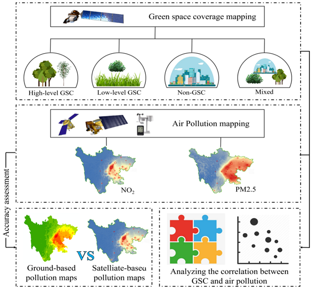
6. Naboureh, A., Li, A., Bian, J., Lei, G., Nan, X., Zhang, Z., Shami, S. & Lin, X. (2024). Green space coverage versus air pollution: a cloud-based remote sensing data analysis in Sichuan, Western China. International Journal of Digital Earth, 17(1), 2383454
Research Article: DOI, WoS, Scopus, Citations (Impact Factor: 3.7 (Q2), CiteScore: 6.5 (Q1), Open Access)
Research Article: DOI, WoS, Scopus, Citations (Impact Factor: 3.7 (Q2), CiteScore: 6.5 (Q1), Open Access)
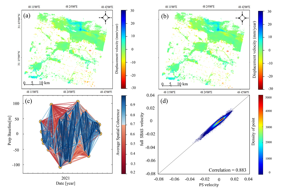
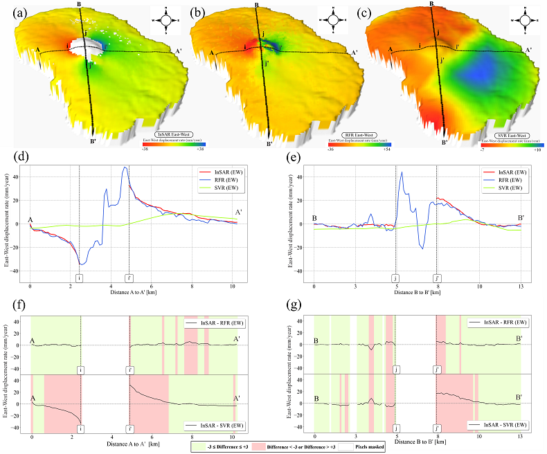
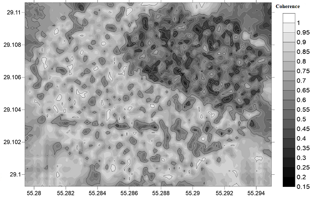
5. Shami, S., Shahriari, M. A., Nilfouroushan, F., Forghani, N., Salimi, M., & Reshadi, M. A. M. (2024). Surface displacement measurement and modeling of the Shah-Gheyb salt dome in southern Iran using InSAR and machine learning techniques. International Journal of Applied Earth Observation and Geoinformation, 132, 104016
Research Article: DOI, WoS, Scopus, Citations (Impact Factor: 7.6 (Q1), CiteScore: 12 (Q1), Open Access)
Research Article: DOI, WoS, Scopus, Citations (Impact Factor: 7.6 (Q1), CiteScore: 12 (Q1), Open Access)
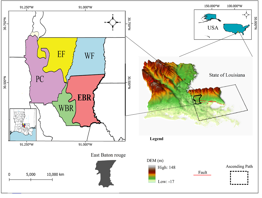
4. Abdalla, A., Shami, S., Shahriari, M. A., & Azar, M. K. (2024). Estimation of land displacement in East Baton Rouge Parish, Louisiana, using InSAR: Comparisons with GNSS and machine learning models. The Egyptian Journal of Remote Sensing and Space Sciences, 27(2), 204-215
Research Article: DOI, WoS, Scopus, Citations (Impact Factor: 4.4 (Q2), CiteScore: 7.1 (Q1), Open Access)
-These authors contributed equally: Ahmed Abdalla and Siavash Shami
Research Article: DOI, WoS, Scopus, Citations (Impact Factor: 4.4 (Q2), CiteScore: 7.1 (Q1), Open Access)
-These authors contributed equally: Ahmed Abdalla and Siavash Shami
3. Khoshlahjeh Azar, M., Shami, S., Nilfouroushan, F., Salimi, M., Ghayoor Bolorfroshan, M., & Reshadi, M. A. M. (2022). Integrated analysis of Hashtgerd plain deformation, using Sentinel-1 SAR, geological and hydrological data. Scientific Reports, 12(1), 21522
Research Article: DOI, WoS, Scopus, Citations (Impact Factor: 4.9 (Q1), CiteScore: 6.9 (Q1), Open Access)
-These authors contributed equally: Mahdi Khoshlahjeh Azar and Siavash Shami
Research Article: DOI, WoS, Scopus, Citations (Impact Factor: 4.9 (Q1), CiteScore: 6.9 (Q1), Open Access)
-These authors contributed equally: Mahdi Khoshlahjeh Azar and Siavash Shami
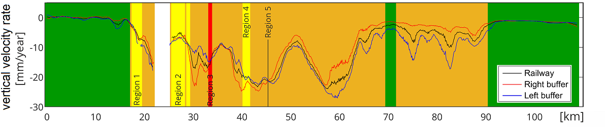
2. Shami, S., Azar, M. K., Nilfouroushan, F., Salimi, M., & Reshadi, M. A. M. (2022). Assessments of ground subsidence along the railway in the Kashan plain, Iran, using Sentinel-1 data and NSBAS algorithm. International Journal of Applied Earth Observation and Geoinformation, 112, 102898
Research Article: DOI, WoS, Scopus, Citations (Impact Factor: 7.6 (Q1), CiteScore: 10.5 (Q1), Open Access)
Research Article: DOI, WoS, Scopus, Citations (Impact Factor: 7.6 (Q1), CiteScore: 10.5 (Q1), Open Access)
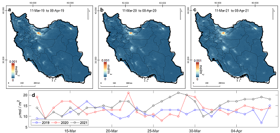
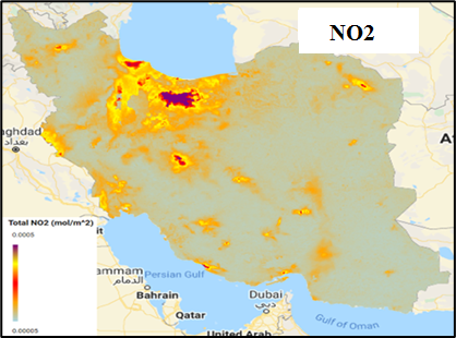
1. Shami, S., Ranjgar, B., Bian, J., Khoshlahjeh Azar, M., Moghimi, A., Amani, M., & Naboureh, A. (2022). Trends of CO and NO2 Pollutants in Iran during COVID-19 pandemic using Timeseries Sentinel-5 images in Google Earth Engine. Pollutants, 2(2), 156-171
Research Article: DOI, WoS, Scopus, Citations (Open Access)
-The journal did not have an Impact Factor or CiteScore at the time of the article's publication
Research Article: DOI, WoS, Scopus, Citations (Open Access)
-The journal did not have an Impact Factor or CiteScore at the time of the article's publication
National Journal Articles (Peer-reviewed)
2. Shami, S., Khoshlahjeh, M., Ghorbani, Z., Moghimi, A., Mohammadzadeh, A., & Sabet Ghadam, S. S. (2021). Evaluation of air pollution contributes for the COVID-19 pandemic in Iran using Sentinel 5 Satellite Data. Journal of Geomatics Science and Technology, 10(3), 135-146
Research Article: Link (In Persian, Open Access)
Research Article: Link (In Persian, Open Access)
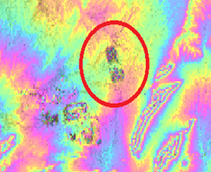
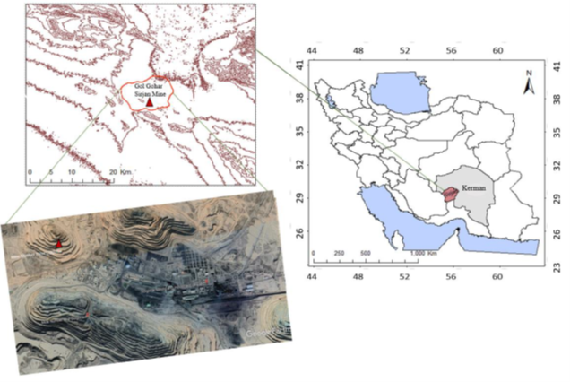
1. Shami, S., Hossainali, MM., & Babaee, S. (2019). Analysis of Large-scale Displacement Using Radar Interferometry Technology in Open-pit Mines (Case Study: Gol Gohar Sirjan Mine). Geospatial Engineering Journal, 10(3), 41-51
Review Article: Link (In Persian, Open Access)
Review Article: Link (In Persian, Open Access)
International Books
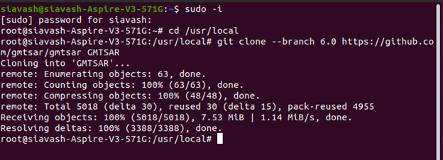
1. Shami, S. (2021). GMTSAR installation and processing Guide - Practical InSAR handbook series
Book: Link (ebook, Open Access)
Book: Link (ebook, Open Access)
National Books
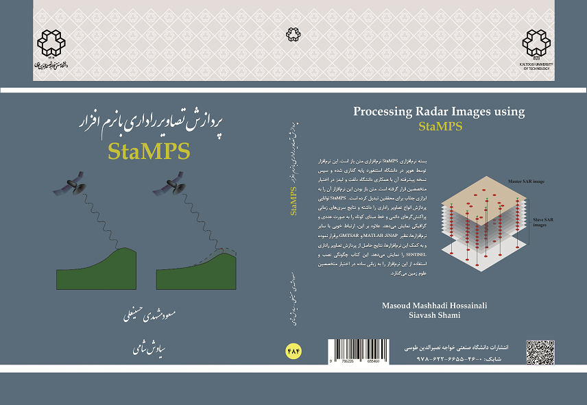
2. Hossainali, MM., & Shami, S. (2020). Processing Radar Images using StaMPS. K.N. TOOSI UNIVERSITY Press
Book: Link (ISBN: 978-622-6655-46-0, In Persian)
-These authors contributed equally: Masoud Mashhadi Hossainali and Siavash Shami
Book: Link (ISBN: 978-622-6655-46-0, In Persian)
-These authors contributed equally: Masoud Mashhadi Hossainali and Siavash Shami
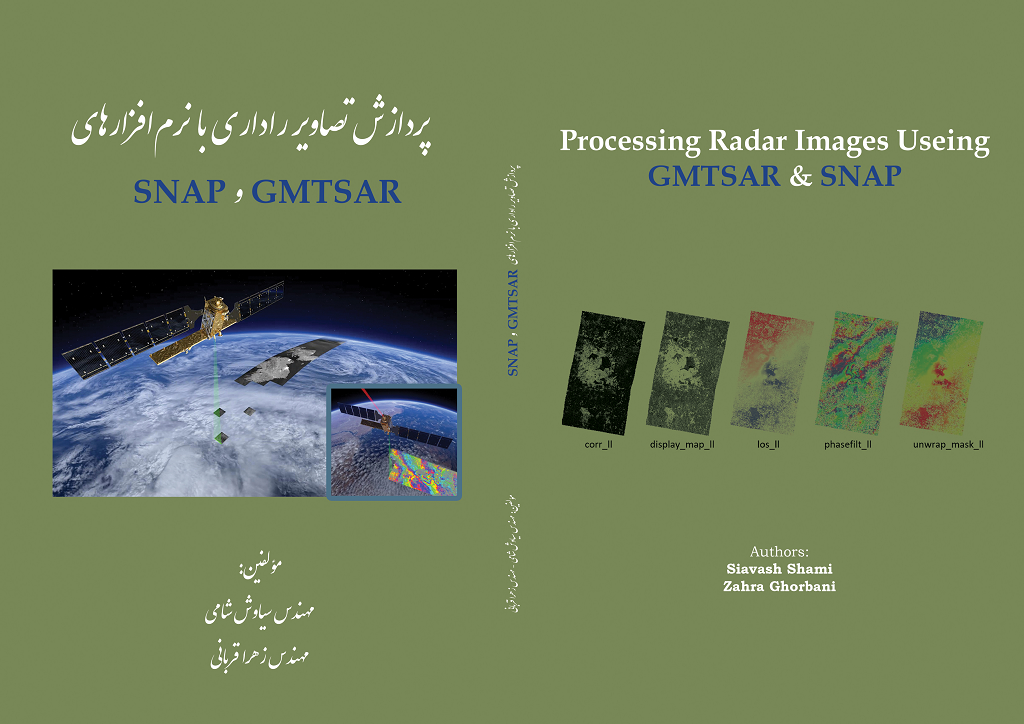
1. Shami, S., & Ghorbani, Z. (2019). Processing Radar Images using GMTSAR & SNAP. Arshadan Press
Book: Link (ISBN: 978-622-251-021-3, In Persian, Open Access)
Book: Link (ISBN: 978-622-251-021-3, In Persian, Open Access)
International Conferences
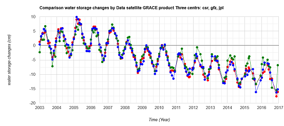
2. Shami, S., & Ghorbani, Z. (2019). Investigating water storage changes in Iran using GRACE and CHIRPS data in the Google Earth Engine system. The International Archives of the Photogrammetry, Remote Sensing and Spatial Information Sciences, 42, 981-984
Conference Paper: DOI, Scopus, Citations (CiteScore: 1.6 (Q2), Open Access)
Conference Paper: DOI, Scopus, Citations (CiteScore: 1.6 (Q2), Open Access)
1. Shami, S., & Ghorbani, Z. (2019). Influence of wavelength radar images in estimation of open-pit mine displacements using radar interferometry technology (case study: Gol Gohar Sirjan mine). 3rd TRIGGER International Conference
Conference Poster: Link
Conference Poster: Link
National Conferences
3. Shami, S., Ghorbani, Z., & Abedi, L. (2018). Calculation of the extracted mines volume using DEM obtained from the Envisat radar satellite images (Case study: Gol Gohar Sirjan Mine). The 4th National Geology and Mining Explorations Symposium
Conference Presentation: Link (In Persian)
Conference Presentation: Link (In Persian)
2. Shami, S., Ghorbani, Z., & Abedi, L. (2018). Persistent Scatterers Time series analysis of radar interferometry to determine the rate subsidence of areas around the open pit mines (Case study: Gol Gohar Sirjan Mine). The 4th National Geology and Mining Explorations Symposium
Conference Poster: Link (In Persian)
Conference Poster: Link (In Persian)
1. Shami, S., & Hossainali, MM. (2018). Analysis of the effect of temporal and spatial baseline of radar images on the amount of coherence for detecting large-scale displacement gradients using interferometric synthetic aperture radar (Case study: Gol Gohar Sirjan Mine). Geomatics and GIT 97
Conference Poster: Link (In Persian)
Conference Poster: Link (In Persian)
* The Impact Factor, CiteScore and Q-value are based on the publication date of the article
Statistics
Total Publications: 17 | International Journal Articles: 7 | National Journal Articles: 2 | International Books: 1 | National Books: 2 | International Conferences: 2 | National Conferences: 3